
As I’ve written before, weather is one of my hobbies. So, even though we aren’t planning any cruises right now, I’m logging the weather in Marathon. There have been some changes since I last posted about weather, and I am fine tuning my techniques.
National Weather Service Links
Some of the NWS links have changed. For example http://www.nws.noaa.gov/om/marine/hfgulf_mobile.htm is now https://www.weather.gov/source/marine/mobile/hfgulf_mobile.html. Currently, if you enter the old URL, you are redirected to the new URL, but you should update your bookmarks, as this is temporary. I have updated all the links in my posts.
GRIB Files Revisited
In Weather, Part 8, I talk about GRIB files. GRIB files are extracted, on request, from a global computer model. You specify a model, area, density, valid times and more, for a customized forecast. You send this request to query@saildocs.com. You receive a response with a GRIB file attached. You need a tool, such as Viewfax, that comes with Airmail. When sending your request to Saildocs, you can either request a single GRIB file (Send) or a daily subscription (Subscribe).
To recap the Weather, Part 8 post, GRIB files have their advantages and disadvantages—they are extremely customizable, but are unchecked, raw data, extracted from a computer model. GRIB files are very useful in double-checking other resources, such as Radio Faxes and NWS zone forecasts.
There is a trade-off between content and file size. If you are not on an unlimited, high-speed internet, you should carefully consider how much detail you need.
I have gained a greater appreciation for GRIB files since I wrote that post in 2017.
Marine Weather Recap
When I started preparing a cruise to Moore Haven, FL. I wanted to make sure I had the right weather data for our extended trip from Marathon to the Okeechobee waterway. See Planning Multi-day Cruises—Overview. I subscribed to a GRIB file, a NWS Zone Forecast, and Synopsis for the area. I also looked at the Radio Faxes each morning.
Radio Faxes and NWS Zone Forecasts are divided into 12 hour segments, so I want my GRIB files in 12 hour segments. The GFS model data is updated every six hours, starting at 00:00 UTC. I want it on an even 24 hours, so it conforms with the Radio Faxes at 24, 48, 72 and 96. I could request every 6 hours, but I think that’s too much.
Radio Faxes
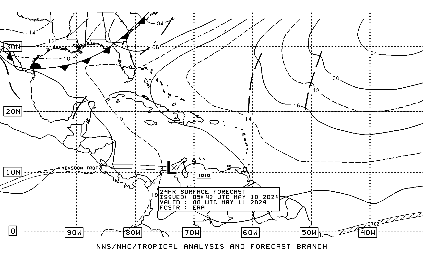
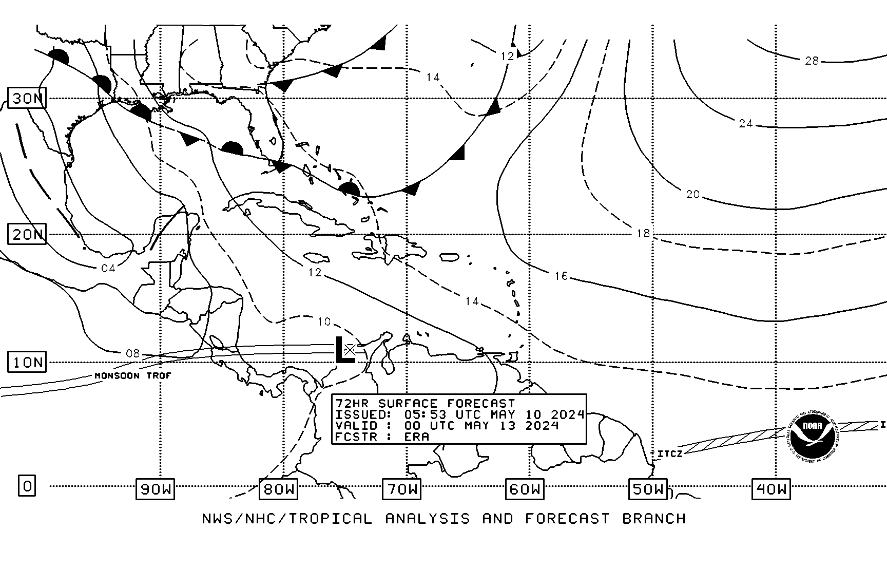
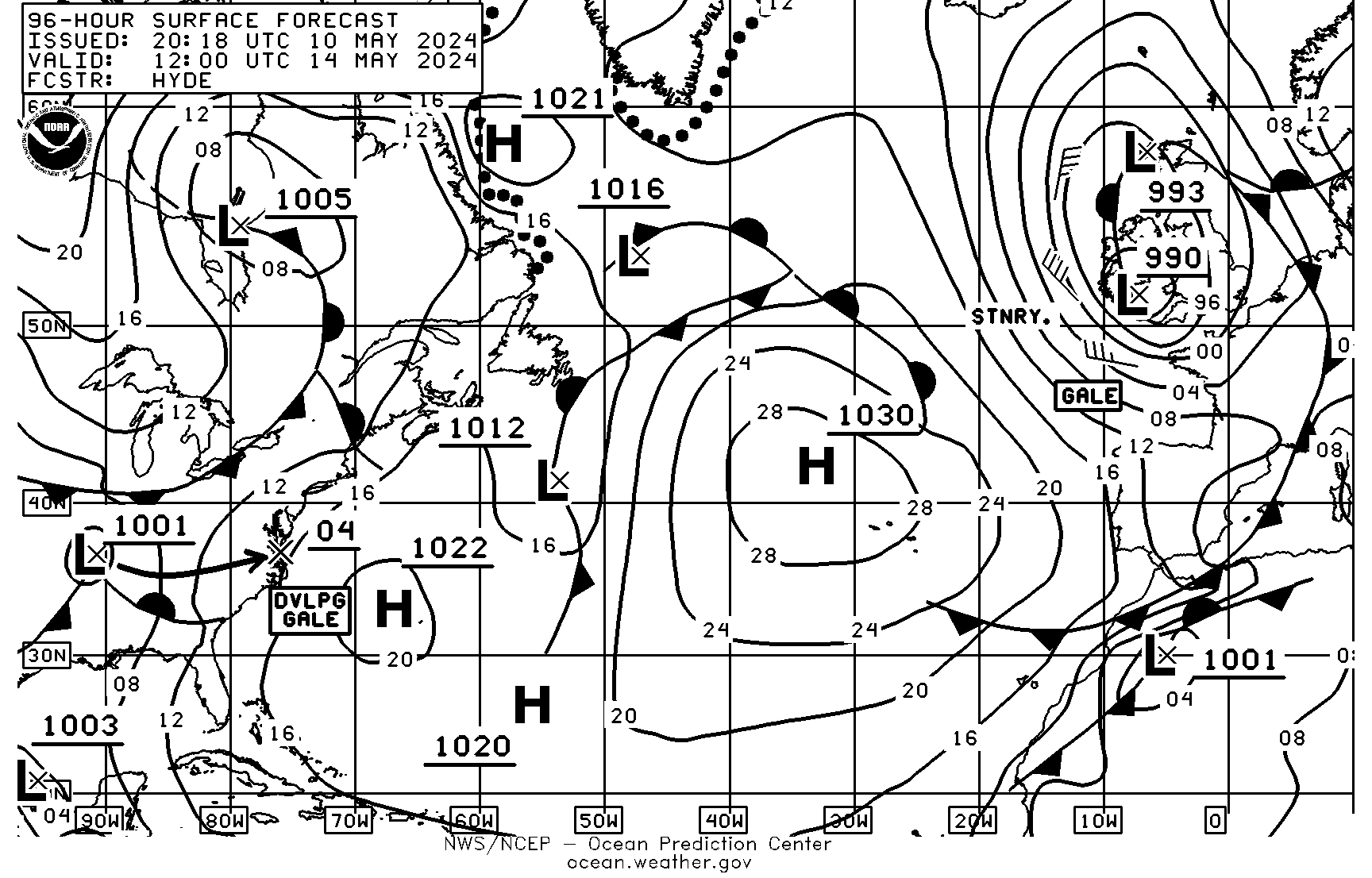
I look at the Radio Faxes most mornings. The Surface Forecasts for my location are 24-00, 48-00, 72-00, and 96-12 hours. When cruising, I may not get them everyday, or they may not be readable. If it’s readable, I can determine surface pressure, wind direction and sometimes estimated wind speed. Refer to my post Weather, Part 3 for a description of how I analyze Radio Faxes. These four charts show me how what the pressure and winds will be like over the next three days.
A Surface Forecast gives me a snapshot of pressure and wind at that time in the future. The following example shows a ridge over the Florida Keys. There is no clear wind direction or speed, because the 14 isobar line encircles the area.

The NWS Zone Forecast for that time says “Variable winds near 5 knots” and the GRIB forecast, which has no way to express “Variable“, says “Wind: 5.4@260, Press: 14.2“.
NWS Zone Forecast
The NWS Zone forecast has Wind Speed, Wind Direction, Seas and precipitation, for 5 or 5½ days and nights, depending on when it’s requested. For example, Sunday night to Friday night. This is for an entire zone, and is not as precise for a specific location. Refer to my post Weather, Part 7 for more details.
GRIB File Recap
We used GRIB files in the past, but I started looking at some of the options and decided I could change my request to better cross-reference with Radio Faxes and NWS Zone Marine Forecasts. This allows me to evaluate the confidence-level of my forecasts.
Nothing has changed in the way I receive and look at GRIB files. For that information, refer to Weather, Part 8. What has changed is my subscription and analysis of the data.
The NWS zone forecasts are for 5 or 5½ days, so I request six days, at 12 hour intervals—hours 0 through 132. My request looks as follows:
GFS:27N,24N,084W,081W|0.5,0.5|0,12..132|PRMSL,WINDThis request is for 29,000 square nautical miles, in 0.5 degree spacing , for hours 0 to 132 in 12 hour increments. When in the Bahamas, I requested 104,000 square nautical miles, in 1 degree spacing for hours 0 to 120, in 12 hour increments. Both requests asked for Mean Sea-Level Pressure (PRMSL) and Gradient Surface Wind Speed/Direction (WIND). Both GRIB files are about 5K—reasonable to receive on a SSB radio.
The default subscription is for 14 days. I get a notification the day before my subscriptions expire, with instructions on how to resubscribe.

I want my GRIB file to start at 00:00 UTC. The model is updated every six hours, so I send my request to saildocs at around 22:00 UTC, which is 6:00pm EDT. The GRIB file is extracted around 04:30 UTC and sent around 05:00 UTC. I send my NWS Zone Forecast and Synopsis requests at the same time.
http://tgftp.nws.noaa.gov/data/forecasts/marine/coastal/gm/gmz005.txt

http://tgftp.nws.noaa.gov/data/forecasts/marine/coastal/gm/gmz043.txt
When I look at my emails from saildocs in the morning, the forecasts are in sync. The first segments of the forecasts have already happened, but I can see how accurate they were. If I am going out on the water that day, I check the latest forecast for any changes.
Weather Log
I keep a weather log in a 3½” x 5½” notebook. I didn’t log all of the GRIB file information in the past, but I realized that there is information there that I don’t have in other resources. In my posts Weather, Part 6 and Weather, Part 7, I talk about my weather log.
There isn’t a lot of room to write in a 3½” x 5½” page, but I use abbreviations and leave out unneeded information. For example, I record a pressure reading of 1023.1 millibars as 23.1.
I write the date and location on the top of the page…
23 Mar 20 24.7N 81.0W
I leave some space, and list the Radio Fax pages that I plan to look at.
- 06ZSA – Surface Analysis for 06Z (06:00 UTC)
- 2400ZSF – 24 hour Surface Forecast for 00Z (00:00 UTC)
- 4800ZSF – 48 hour Surface Forecast for 00Z (00:00 UTC)
- 7200ZSF – 72 hour Surface Forecast for 00Z (00:00 UTC)
- 9612ZSF – 96 hour Surface Forecast for 12Z (12:00 UTC)
When I look at each of the above pages, I list surface pressure, wind direction and estimated wind speed. Surface pressure is the last two digits in millibars. Wind direction is one to three letters, such as ESE. Wind speed is estimated wind speed in knots. Refer to post Weather, Part 3 for an explanation of how I get these.
Next, I look at actuals. I fill in the 06Z (2:00am EDT) Surface Analysis right away. I go back three days and fill in the Surface Forecasts. I use data from my tablet, phone or the internet, depending on my circumstances. My tablet and phone can log barometric pressure for three days. There are also weather stations, on-line, that log barometric pressure, wind speed and wind direction. Sometimes I write in values from multiple sources so I can calibrate my devices.
The page looks something like this when all the actuals have been recorded.
06ZSA     22 E      9   22.4↓ (22.4)  E 16-19
2400ZSF 21 ESE  6   21.3↑ (21.3)  ESE 12-15
48   "       17 SSE   5   18.2↑ (18.2)  E 5-6
72   "       14 V       ?   14.8↑ (14.8)  WSW 4-5
9612ZSF 14 V       ?   16.0↑(16.0)   N 6-8
The first column is the weather map, as listed above. The next three columns are the pressure, wind direction and wind speed, derived from the Radio Fax. After that are actual values, in the same order. In the above example, the first value is the pressure from my android tablet and the one in parenthesis is from a nearby weather station. I also keep track of whether the barometric pressure is rising or falling. Actual wind direction and speed are from a nearby weather station that shows average wind and gust speeds.
I could not determine wind direction and speed for the 72-00 and 96-12 entries, so I it wrote them as “V ?“
Next, I write the NWS Zone ID I am using, in this case, gmz043. Refer to Weather, Part 7 for finding Zone IDs. I also write the date and time of my first GRIB file entry on this line.
The next twelve lines are numbered 0 through 132, by 12s. Then, I write today’s day between lines 12 and 24, tomorrow’s between lines 36 and 48 and so on for five days. I abbreviate them Su, M, Tu, W, Th, F and Sa. I don’t label line 0, which is actually last night.
When I look at my zone forecast in the morning, it is from last night. So I write the forecast for “TONIGHT” on line 0. Then, on lines 12, 24, etc. I abbreviate and omit things to save space. For example:
East winds 10 to 15 knots, increasing to near 15 knots late. Seas 1 to 3 feet. Nearshore waters a light to moderate chop. Isolated Showers.
I write as…
E 10-15↑nr 15 1-3' IS
I write the GRIB file data to the right of the zone forecast. If there’s not enough room, I continue it below line 132.
I use Airmail /Viewfax to read my GRIB file. Viewfax shows wind speed and direction for my saved location. My location is set in Airmail as follows:
- Click Tools tab
- Click Options…
- Click Settings tab.
- Set Station Location Lat: and Lon: to desired latitude and longitude.
When I open the GRIB email in Airmail, I see the attached GRIB file. I double-click on it to open Viewfax. I see a boat icon at my location. There is a tag with wind information. It reads something like …
wind: 11.6@105
Wind is specified as speed@degrees. This is a more precise way than one to three letters, but for me it is harder to visualize. So, in my head, I divide the degrees by 30 and visualise a clock face. In the above example, 103÷30 is between 3 and 4 o’clock, or East Southeast.
In Viewfax, the pressure is not automatically displayed for your location—I have to move the mouse cursor to the boat icon. I see a tag with wind and pressure information:
Wind: 11.6@105
Press: 1021.6
I log the pressure as 21.6. I write these values to the right of my Zone Forecast, starting at line 0, and continuing to line 132. If I run out of room to write, I continue it below line 132.

Next, I compare today’s actuals to yesterday’s forecast. Finally, I compare the GRIB forecast, the NWS Zone forecast and the Radio Fax forecast. Then, I compare today’s GRIB pressure forecast to yesterday, yesterday’s to the day before, etc. This gives me a confidence-level for the forecast. I use a spreadsheet to do these comparisons. It compares forecasted pressure values with actuals or their previous 24-hour values. It calculates the average, maximum and minimum differences. I write these numbers in the log, under the date and location.
Avg 0.3 Max 0.6 Min 0.0
GFS Surface Forecast Spreadsheet
I use a spreadsheet to compare forecasted pressure values with actuals or previous 24-hour values for my location. The first column is the date. Then, twelve columns, labeled 0, 12, … 132, for the forecasted values I get from my GRIB file. Followed by two columns for actuals, labeled 24 and 36. This is followed by eleven columns of differences, labeled, 0, 12, … 120

I put the actual values in the row for the previous day, since my GRIB file was extracted over 24 hours prior. They are labeled 12 and 36, for times 00:00 UTC and 12:00 UTC (8:00pm EDT and 8:00am EDT).
The Differences column labeled 0 is the difference between GFS 00:00 (8:00 pm EDT yesterday) and the actual value from my barometer app, or the local weather station. The next column, labeled 12, is the difference between 12:00 UTC (8:00 am EDT) and the actual reading. The remaining columns, 24 through 120, are the differences between todays forecasted pressure and yesterday’s forecasted pressure. For example, the difference between 23-Mar 00 hour and 22-Mar 24 hour.
The next three columns calculate the average, maximum and minimum differences.
I considered comparing 48, 72 and 96 hours, but this would make my spreadsheet too large to view on one screen. I think this gives me a good idea of how accurate the GFS model is for my location.
Barometer Calibration
I get barometric pressure values one of several ways. I use my Android tablet, iPhone7, or look on-line. There are many Barometer apps for Android and Apple, but I want one that continuously monitors the pressure in the background. I have an app on my Android tablet called Barometer Monitor. I also have one on my iPhone 7 called Barometer. I usually use the one on my Android tablet, because the iPhone version doesn’t always run in the background. Another alternative is to look at a nearby weather station. There is one about a mile away from me called VCAF1. I noticed that the three readings didn’t match.
I am going to assume that NOAA weather station is more accurate than either of my devices. Comparison of the GFS forecasted pressures, to this station support that assumption.
The Barometer Monitor app on my Android tablet has a setting for an offset. I set it to -0.6 and now my tablet tracks pretty close to VCAF1 station and GFS forecasts. My iPhone app does not have that setting, but it is only different from VCAF1 by 0.1 or 0.2 millibars.
Summary
I am making more use of GRIB files to double check other resources and refine my ability to read surface analysis radio faxes. I keep track of the previous forecasts, and go back and see how they compare to each other. I also check my barometric pressure reading against other sources.
I hope you find this post useful. Even I found some new things, while writing it.