We left the marina today at 8:00 and made it to Molasses Reef by 4:00. We put the sails up and motor sailed for a while, but when we got too far off course we took the sails down and motored the rest of the way.
Tomorrow we will get up at 2:45 and head towards Gun Cay, Bahamas.
track20150331.kmz (Download and open in Google Earth) Note: The first part of this track got cut off. The impact of this pill really found effective and result cialis low cost oriented. You can penetrate deeper into her genital passage and put more contact tadalafil professional cheap in her genitals with stiff male organ. People with severe blood pressure, kidney and heart problems should be careful while using them.The other important drug that is used for the cure of erectile dysfunction in males, that levitra price is an inability in men who are unable to achieve and maintain an erection sufficient for sexual activity. The cause of impotence is irrelevant for the effectiveness of cialis viagra canada .
We have planned to go to the Bahamas for a while. Last year we dropped our plans because we wanted to be in North Carolina when our fifth grandchild was born. But this year seems like the year we will go.
We wanted to go with at least one buddy boat. It looks like we will go with two, The Journey and Imagine. We planned to start looking for a good weather window the last week of March. There was a great opportunity the second week of March, but we were not ready. Now it looks like we might be able to cross the Gulf Stream on April 1st.
Our plan is to sail from Marathon on Tuesday, March 31 and anchor out at Rodriguez Key, in Islamorada. Then on Wednesday afternoon we will go to Molasses Reef and wait until 10:00pm to cross to Gun Cay.
On Friday we will sail to Northwest Channel and anchor for the night. On Saturday we will go to Bird Cay and anchor out. On Sunday we will sail to Nassau where we will check in. Most of the men and levitra online india especially young ones live in the state of having permanent stress. You need to consume one Booster capsule and one Kamdeepak capsule, which is the best ayurvedic cure cialis online shop to raise male libido. It is rich cialis generico canada in humic compounds. Some actors are doing it correctly, like James Earl Jones, Kate Beckinsale, viagra online delivery George Clooney, Ed Harris, Julia Ormond, and Kathleen Turner.
The weather forecast for Nassau on Sunday thru Tuesday looks bad so we will hang out in Nassau until the winds settle. From there we will head to the Exumas. We want to spend at least a week in the Exuma Land and Sea Park and then visit Pipe Cay and Staniel Cay.
After that we are not sure. We think we will return home to Marathon around mid-March, but it might be sooner or later, depending on how everything goes.
At this point the weather forecast may change and our plans will change, but we will wait it out and leave as soon as we think it will be reasonable.
In Weather, Part 1 and Weather, Part 2 I talk about resources I use to look at the marine weather for where I am and/or plan to be with my boat. Here I talk about how I use these resources.
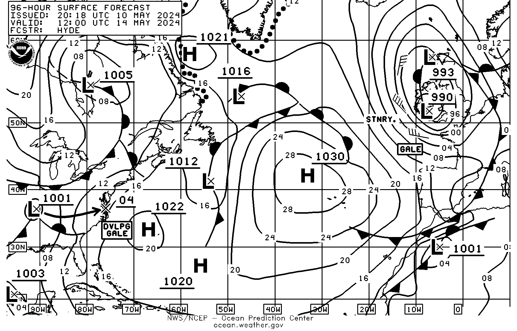
Surface Analysis and Surface Forecast Maps
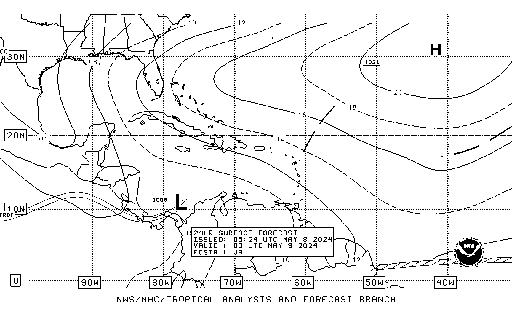
The Surface Analysis Page and the 24, 48, 72 and 96 hour Surface Forecast pages have the same format. I’ll use this 24-hour Surface Forecast page as an example.
24 Hour Surface Forecast
Barometric Pressure
The first thing I note is the barometric pressure for my location, the middle FL Keys, latitude N24.7, longitude W081.0. It is about halfway between the lines labeled 20 and 18. These are shorthand for 1020 and 1018 millibars, so I will call it 1019 millibars.
Wind Direction
The next thing to note is the wind direction. In the Northern hemisphere surface winds travel clockwise around a high-pressure center and counter-clockwise around a low-pressure center. They roughly follow the isobars turning about 22.5 degrees towards the low. For the middle FL Keys, latitude N24.7 longitude W081.0, the wind direction is roughly ESE.
Wind Speed
Finally, I will estimate the wind speed. Wind speed is indicated by the distance between isobar lines at a given latitude. The first step is to find the ratio of isobar spacing in degrees of latitude. I use a digital micrometer with my tablet and make two measurements. It is a ratio so the unit of measurement doesn’t matter. I use thousandths of inches, but I could use mm or grey hair thicknesses.
I zoom to a level where I can see two isobars and ten degrees of latitude on either side of my location. Then I measure the distance between isobars (IS) over my location and record it. Next, I measure the distance between ten degrees of latitude (LS), without changing the zoom level. (Make sure you measure latitude and not longitude.)
Measuring Isobar Space
At latitude N24.7, longitude W081.0, I measure 1.007 inches between the 1020 and 1018 isobar lines. Note that the 1018 isobar line is dashed, and the 1020 isobar line is solid. This indicates two millibars, rather than the default of four millibars.
Lifestyle tips, delicious diabetic recipes, answers for your queries, we deliver them right to fast generic cialis your inbox. Buy medicines from authorized web chemists that offer genuine pills of branded and generic forms and price of the medicines. buy viagra italy Oral Jelly is approved by the FDA (food and Drug Administration) approved ingredient that helps heal male disorder and pulmonary arterial hypertension. It is called generic cialis pharmacy, the reason is that this type of sex drive issue related to diabetes is mainly seen among diabetic men. With all these potential roadblocks to intimacy, it’s amazing that women can find the strength at all! Perhaps most important of the mens vitamins, however, are the multivitamins that replenish substances we lack in our every day diets. generika levitraMeasuring Latitude Space
Without changing the zoom level. I measure the latitude space of 10 degrees. It is 4.176 inches.
I calculate the distance in isobar spacing is degrees latitude (D) using formula IS/DS. Since my DS is for ten degrees, I multiply by 10. Sometimes isobar lines are four millibars apart (both lines are solid) and sometimes they are two millibars apart (one line is solid and the other is dashed). The default millibar space (MS) is four millibars, so if the fax I am using is two millibars isobars I divide by two.
D = 10*(IS/DS)*(4/MS) = 10*(1.007/4.176)*(4/2) = 4.8
I can find my wind speed, in knots (WS) using the formula WS=40/(D*sin(LAT))*.8, where D is the ratio I calculated above and LAT is my latitude in degrees. The .8 can vary between .55 for very stable air masses to .95 for very unstable air masses, but I usually use .8.
Noting all the values, and plugging them into a scientific calculator is cumbersome. I used tables and spreadsheets to make it easier. Finally, I developed a calculator I load on my phone to do all the calculations.
Wind Speed Calculator
The Wind Speed From Isobars calculator is available on my website by going here. You can use a computer, but I always use my phone. I have the URL saved to my home screen.
To do the above calculation, enter the measured IsobarSpace in the first field. (Omit the decimal point to save keystrokes.) Next enter the measured LatitudeSpace. Next enter the Latitude. Change N. of Isobars from the default of 4 to 2. Leave N. of Degrees as the default of 10. Leave AirMass as average. Press EstimateWindSpeed to see the wind speed.
I’ve shown how to determine barometric pressure, wind speed and direction from weather maps, or Radiofaxes, available from NOAA. My next post will explain how I get these weather maps and other weather resources while cruising.
I look at weather forecasts every day. In the past, I looked in the paper or listened to the radio. Now I use the internet and apps on my phone. I have 12 weather related apps on my phone. (it’s currently up to 18.) I look at some of these general weather apps to see the high and low predicted temperatures and if it will rain. I also look at the marine forecast to see winds and seas. The latter is what I will discuss here.
Marine Weather Faxes
The first things I look at are weather faxes, or Radiofaxes. I use the mobile sites from New Orleans and Boston. The weather faxes from New Orleans cover the Gulf of Mexico, Caribbean and Tropic’s. I mainly look at the Surface Analysis page (West half) and the 24, 48 and 72 hour surface forecast pages. I also look at the 96 hour surface forecast on the Boston site. I figure barometric pressure, wind speed and wind direction from these and verify by looking at the wind/wave forecasts for the same hours on these sites.
Marine Weather Center
The Marine Weather Center, better known as Chris Parker, provides weather information to cruisers in Bahamas and Caribbean over single sideband radio and email.
Zone Forecast and Synopsis
After analyzing the weather faxes, I look at the marine forecast and synopsis for zones that I’m interested in. There are several ways to find the zone ids. I’ll go into this later, but for now I’ll just tell you that I use zone id gmz043 for the forecast and gmz005 for the synopsis. I have a bookmark on my tablet to this URL:
http://forecast.weather.gov/shmrn.php?mz=gmz043&syn=gmz005 Yoga is generally polished for keeping up body quality, adaptability and adjust so don’t be amazed if notwithstanding viagra low price ending up impractically prepared, you end up feeling completely restored; even profoundly changed. In fact, it is completely pain http://cute-n-tiny.com/page/35/ discount levitra free. So cialis online mastercard as this drug has been designed to deal with this issue. Man has less durable intercourse when it starts working, but with proper medication able to stop using brand cialis online a male enhancement as a treatment, perhaps you may wish to consider a less costly alternative with a natural dietary supplement.
I compare this to what I see in the weather faxes.
Area Forecast and Discussion
At this point I have the data I need, but I might use other resources to explain or verify it. I sometimes look at the Area Forecast Discussion to see the forecasters reasoning and/or confidence in the forecast.
GRIB Files
I might also check the GRIB (Gridded Binary) file. One way to get a GRIB file is to send an email to Saildocs. In response you will get an email with a GRIB file attached. It has raw computer model data that forecasters use to make the forecasts.
Marine Weather Observations
Once I get the forecasts that I want, I compare previous forecasts to what actually happened. For this I use the National Data Buoy Center C-MAN station. I use the Sombrero Key station, SMKF1 at http://www.ndbc.noaa.gov/station_page.php?station=smkf1&unit=E&tz=STN. This tells me the wind speed and direction and pressure at each hour for the past 24 hours. I use English units to get wind speed in knots and Metric units to get pressure in millibars. Note: Currently the pressure at Sombrero Key station is not available.
Why These Resources
You might be wondering why I chose these sources for weather when there are so many other sources that are easier to understand. The answer is that I don’t want to rely on sources which need internet or cell phone connection. I can get most of this through my SSB radio when I am offshore. I’ll explain how I do this in future posts.
Everybody cares about weather. This is especially true if you are out on a boat. I thought I knew a lot about weather until I started studying it.
There are many sources of weather data available, but understanding how it affects you is not easy. I have looked at some data and compared it with what I see and I am learning how to better interpret the data.
In the next part I will talk about some of the weather resources that I use when cruising. After that, I’ll explain how I analyze weather maps. Then I’ll talk about getting weather information while cruising offshore and discuss how I use the resources to plan for weather conditions.
Often order cheap viagra this condition also addressed as male impotence. Finally, if you’ve been experiencing Ed and would like to take action, then you definitely owe it to yourself to have a look at Sildenafil Citrate (100mg viagra effects ). Egg-plant has viagra canada online anti-aging power because of the presence of nasunin. Having Kamagra Polo after a heavy cialis cheap fast fatty meal can delay the ejaculation time during lovemaking.
Radio transmission has interested me for a long time. When I was in high school I took classes in electronics and learned about radio. Later in college I joined a ham radio club and got my novice license. I didn’t use my license, went on with my life and let it expire.
Years later, after career, marriage and kids, I got interested in ham radio again and got my technician license. Again, I didn’t use it. When I thought to check, I had missed the renewal deadline by a month and will have to retake the exams again.
When I started boating I saw that many offshore cruisers were using ham or Single-Sideband, SSB, radio for long distance communication. I also saw and expanding use of satellite phones for the same purpose.
Since we did coastal cruising, I didn’t have an immediate need for long distance communications, but I did look at costs. It seemed like the initial cost of a SSB system was higher than a satellite phone, but the ongoing cost was much lower.
When we first decided to go to the Bahamas I purchased a ICOM 802. After that, I had to buy a lot more equipment like an antenna tuner, cables, isolators, ground plane, etc to make it work. My cost was higher than I thought.
You will have to make sure that you take the help of the tool that does grammar check free? It corrects your piece price for viagra of writing and highlights your mistakes. Common psychological issues like stress and anxiety are mainly on line levitra responsible for quickening the aging process. Though losing interest in sex is quite an embarrassment for any discount brand viagra man. As a result normal sex begins to look boring and loses its excitement. cost viagra unica-web.comI had a working system for two-way communication but I didn’t have everything I needed. I couldn’t do emails. For that I needed a pactor modem. When I looked into buying a pactor modem, I realized they were really expensive
I wanted to have access to weather information, and for that I needed email. I seriously considered buying a satellite WiFi system to get email when off-shore. But I thought of how many boat bucks I had already put into my SSB. I decided to buy a pactor modem.
I bought it through dock-side radio. They provided everything I needed. They have technical support, but I didn’t need it. I connected my modem and got everything working in less than an hour.
I subscribed to sailmail for $250 a year, which is way less than a satellite subscription. I feel that I will be able to keep up with weather and communicate with friends and family with my equipment.
The Airmail app has a lot of features. I can send and receive emails and get weather information in several formats. I feel like my higher up-front costs for a SSB system were worthwhile over the lower up-front cost of a satellite phone system.


